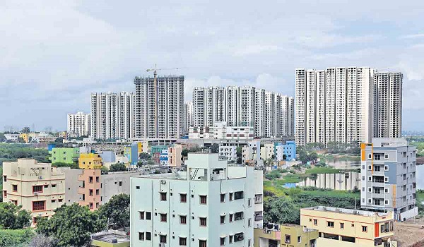
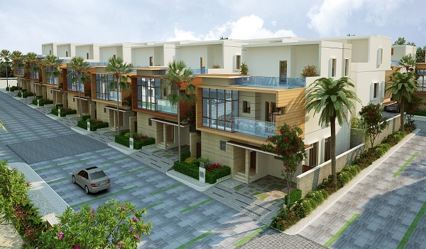
The Prestige City Hyderabad Location

Location is one of the most important factors to consider while investing in real estate. A property's location directly impacts its value, rental yield and capital appreciation potential. For investors, understanding the importance of location is an important part of making a successful investment in real estate. Rajendra Nagar, in the southern zone of Hyderabad, is one of the most preferred destinations for potential buyers and end users because of the convenient and comfortable lifestyle provided by the location.
The Prestige City Hyderabad is situated in South Hyderabad, Telangana 500052, at Rajendra Nagar, next to Umda Nagar. The area's advanced physical and social infrastructure and proximity to Hyderabad's major economic districts make it noteworthy. The key intersections in this region include
- Outer Ring Road
- Hyderabad Elevated Expressway
- National Highway 7
Address

The Prestige City Hyderabad's address is Rajendra Nagar, near Umda Nagar, South Hyderabad, Telangana 500052. This location provides effortless access to all of Hyderabad's other areas and all necessary services. The neighbourhood is a great place to live since it has a robust social infrastructure that can accommodate all of the needs of its residents.
Connectivity

A good location should be close to public transport hubs such as bus stands, metro or train stations. The further the property is from the mass transit hub, the lower the property's value. How simple it is to access a range of services and modes of transportation can significantly impact a location's attraction and long-term worth. Connectivity improves tenants' overall quality of life in residential complexes.
Through a variety of transit options, The Prestige City Hyderabad residents have simple access to all of the city's key areas. According to their preferences, commuters can select the most convenient option. The well-established infrastructure, vibrant neighbourhood, and convenient access to essential amenities set the project location apart from other areas in the neighbourhood.
Airport connectivity
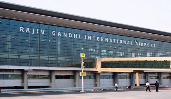
Convenient access to the airport is provided via NH 44 and Airport Approach Road from the project area. The drive time from the area is just 15 min. The residents can choose the path that brings them to their destination easily.

- Rajiv Gandhi International Airport – 10.7 km
Metro Connectivity
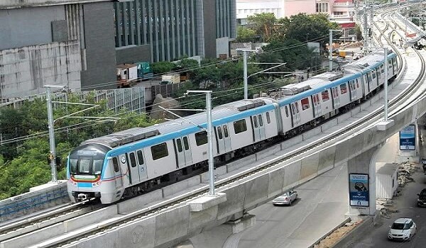
Due to the project location's excellent connectivity to prominent metro stations, homeowners can easily commute by metro rail. Corridor IV, often known as Hyderabad Express Metro, is an authorized Hyderabad Metro line that runs from Rajiv Gandhi International Airport to Raidurg metro station. It is one of the three operational lines of the Hyderabad Metro, spanning 27 km and featuring 23 stations. The Blue Line runs from Raidurg in the west to Nagole in the east, passing through significant places, including HITEC City, Madhapur, Jubilee Hills, Ameerpet, and Begumpet.

- Rajendra Nagar metro station/ Satamrai – 2 km
- Shamshabad metro station – 7 km
Rail connectivity
The project's location provides effortless access to major city train terminals. Railroads have the potential to reduce traffic congestion as well as the environmental impact of transportation.

- Budwel Railway Station – 2 km
- NPA Shivram Pally – 3.5 km
Bus Connectivity
Getting to the city's main bus stops from the project site is convenient. The advantages of bus travel, such as its low cost, convenience of use, lack of stress when driving, environmental friendliness, social opportunities, and hassle-free travel, make it a desirable choice for both short and long distances.

- Budvel Bus stop – 1 km
- A G Campus bus stop – 1.4 km
- Gaganpahad bus stop – 1.5 km
Road Connectivity
The project location's proximity to important linking and arterial roadways sets it apart from other well-developed neighbourhoods. The PVNR Express Highway, which links Mehdipatnam and Banjara Hills, is only 5 minutes away, while the Outer Ring Road, which links the Financial District, Secundrabad, and Hitech City CBD Areas, is 10 minutes away.

- Budvel bus stop – 1 km
- A G Campus – 1.4 km
- Gaganpahad bus stop – 1.5 km
The place offers easy connectivity to major roads such as 5 Minutes to PVNR Express Highway, which connects to Mehdipatnam & Banjara Hills, and 10 Minutes to Outer Ring Road, which connects to Hitech City CBD Areas, Financial District, and Secundrabad.
Cab services

The location provides easy access to taxi services for residents who would prefer to employ private vehicle services like a cab facility. It's easy to get a cab service in such a busy neighbourhood.
Key Distances
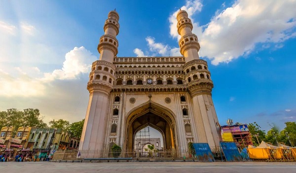
Charminar – 13.9 km (via NH 44 and Inner Ring Road)

The Charminar, a historical landmark, was constructed in 1591. This landmark represents Hyderabad. The four pillars that encircle Charminar represent the four caliphs. These pillars, or minars, are 48.7 meters high.
There are intricately carved rings dividing each of the building's four stories. The earliest mosque in Hyderabad is believed to be on the top floor of the Charminar.
Falaknuma Palace – 11 km (via NH 44)

Falaknuma Palace also referred to as the "mirror of the sky," was built 2000 feet above the ground in the clouds to reflect the ever-changing moods of the sky. It is dispersed among 32 acres of land and 19,400 square meters.
The ten-year conversion of a palace by Taj Hotels is true to its promotional material. The vast palace grounds include everything one might want for an upmarket property.
Chowmahalla Palace – 11.4 km (via NH 44)

Four palaces are referred to by the term Chowmahalla. While Nizam Salabhat Jung started work on the palace in 1750, Nizam Afzar-ud-Dawla Bahadur saw that work was finished between 1857 and 1869.
Aspan Chowk Road on the south and Laad Bazaar on the north included the 45 acres of land the palace originally occupied. Iranian Teheran's Shah's Palace is mirrored in the Chowmohalla complex. The majestic Durbar Hall, or Khilwat, is one of the palace's two exquisite courtyards that are home to attractive residences. Fonts and gardens accentuate the beauty.
Golconda Fort – 16 km (via Narasimha Rao Expressway)

Golconda served as the major capital of the Qutub Shahi dynasty. The inner fort has crumbling palaces, mosques, and a pavilion perched atop a hill, about 130 meters above the ground, offering a panoramic view of the surrounding structures.
Golconda Fort is undoubtedly one of India's most beautiful fortification complexes. The fort finally crumbled into rubble in 1687 following an eight-month blockade by Mughal emperor Aurangzeb, who ended the Qutub Shahi empire and captured the last Golconda king, Abul Hassan Tana Shah.
Salar Jung museum – 17.2 km (via NH 44)

The Museum is a kingly feast for art connoisseurs, with its 43,000 artworks and 50,000 priceless volumes and manuscripts. Rare manuscripts, a founder's gallery, and artwork from children from the Middle East, India, and Europe are among the holdings.
With the most precious materials, Nawab Mir Yousuf Ali Khan gradually turned this extraordinary collection into priceless art.
Hussain Sagar – 21. 2 km (via Narasimha Rao Expressway)

It's the biggest manmade lake in Asia. Hussain Sagar Lake was founded in 1562 AD, during the reign of Ibrahim Quli Qutub Shah. The lake has a heart-shaped formation. It was built on a Musi River tributary and is known as Hussain Shah Wali.
NT Rama Rao, the previous CM of the state of Andhra Pradesh, is the one who designed the Buddha statue in the lake. He was so impressed by the U.S. Statue of Liberty that he gave Hyderabad, the capital of Andhra Pradesh at the time, a sculpture that would become a well-known monument.
Lumbini Park -22 km (via NH 44)

Lumbini Park, a well-liked lakeside park covering 7.5 acres (3 hectares), has speedboats, picnic areas, a musical fountain, and a 3-D laser display. Take a stroll along the banks of Hussain Sagar or plan to stay all day to enjoy the park's many attractions, which include nighttime light displays.
Rajendra Nagar

A thriving neighbourhood in South Hyderabad, Rajendra Nagar, is proof of the city's ever-expanding metropolitan area. This neighbourhood has gained popularity among residents and investors thanks to its well-balanced mix of modern and historical elements. One of the main features of this place is its strategic location. Its convenient location between the city centre and major transportation hubs facilitates access to all parts of Hyderabad.
Major educational institutions, medical facilities, retail establishments, banks, and other requirements are conveniently positioned nearby. Future developments in the real estate market should be encouraged by improved accessibility and planned social enhancements, which should reduce commuting times and boost connectivity with neighbouring areas.
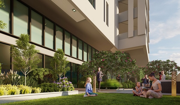
Over time, the area has seen significant infrastructure development. The area's overall quality of life has improved, and the property value has increased as a result of this growth. This vibrant and bustling neighbourhood in Hyderabad offers a cosy, contemporary living while holding on to its traditional and cultural origins. Prestige Group purposefully positioned this opulent township project in these immaculate surroundings, providing every comfort to the occupants.
Rajendra Nagar and its connectivity
Rajendra Nagar has a significant edge over other Hyderabad cities due to its proximity to Rajiv Gandhi International Airport and easy access to the national highway. There is a substantial convergence between the Outer Ring Road, National Highway 7, and the Hyderabad Elevated Expressway. This area is also traversed by the Srisailam Highway, which makes local commuting easier.
The project region has easy access to several reputable IT parks, such as CVK Tech Park (29 km), Mindspace Madhapur IT Park (21 km), and International Tech Park Hyderabad (20 km). The project location is connected to Hyderabad's well-known employment hubs by the Nehru Outer Ring Road, which runs through Gachibowli (19 km), Manikonda (19 km), and Hitech City (21 km).
Air connectivity
Rajiv Gandhi International Airport, popularly known as Hyderabad Airport, has won over 100 medals for excellence in various areas, including corporate social responsibility, environmental sustainability, operational effectiveness, safety, and corporate governance. Consequently, it is one of the world's most ornamented airports.
Situated in Shamshabad, Rajendra Nagar is easily accessible from the Rajiv Gandhi International Airport. About 16 km separates this location from the airport, which is easily accessible.
Metro connectivity
The Hyderabad Metro Rail Project will soon expand with the completion of Hyderabad Metro Phase 2 in Blue Line to enhance Hyderabad's public transportation infrastructure. The project entails building new metro lines as well as extending the length of current lines, adding up to about 67 km.
The Hyderabad Airport Metro project will reach the Rajiv Gandhi International Airport (RGIA) terminal in Shamshabad by travelling along the Gachibowli Main Road and the Outer Ring Road. At an estimated expense of Rs 6,250 crore, the State government anticipates the project will be operational by the end of 2025.
There will probably be one subterranean station and nine elevated stations along the Hyderabad airport metro route. The State government's shared graphic makes clear where the airport corridor metro will pass through major areas such as,
- Manchirevula
- Rajendranagar
- Shamshabad
- Airport Cargo
- Airport Terminal
Rail connectivity
There are 212 railway stations in Telangana, five of which are main. Those five major stations in Telangana are;
- Secunderabad Junction
- Hyderabad Deccan
- Kacheguda
- Warangal
- Kazipet Junction
The Hyderabad segment is 653 km (406 miles) long with 104 stops. The division is responsible for the upkeep of almost all railway assets and properties in the twin towns of Hyderabad and Secunderabad. Hyderabad's principal train stations are Budwel and NPA Shivram Pally. It helps the residents of Rajendra Nagar have rail access.
Hospitals near The Prestige City Hyderabad

- Shadan Hospital – 10 min
- Trident Hospital – 10 min
- LV Prasad Hospital – 10 min
- Olive Hospitals – 15 min
- KIMS Hospitals – 25 min
- Apollo Hospital – 25 min
- Germanten Hospital – 20 min
Educational Institutions near The Prestige City Hyderabad

- Solitaire Global School - 7 min
- EDIFY World School – 11 min
- Basil Woods School -12 min
- Greenwich Academy – 16 min
- DPS Aero City – 20 min
- Mahaveer Institute of Science & Technology – 16 min
- Vasavi College of Engineering – 25 min
- Lords Institute of Engineering & Technology – 30 min
Shopping Centres near The Prestige City Hyderabad

- Mantra Mall – 9 min
- South India Shopping Mall – 11 min
- Asian Cinemas MCube Mall- 15 min
- GVK One Mall Banjara Hills – 30 min
Tech Parks near The Prestige City Hyderabad

- GMR Aerospace & Industrial Park – 20 min
- GMR Business Park – 20 min
- Aero City – 20 min
- HCL Talent Care – 25 min
- Financial District – 30 min
- Mindspace SEZ – 35 min
- Hitec City – 40 min
- Hyderabad Pharma City – 40 min
Frequently Asked Questions
1. Does the project allow easy access to basic amenities?
The project is located in a strategic place with easy access to all the basic amenities, including international schools, multispeciality hospitals, entertainment hubs and employment parks.
2. Which is the nearest airport to The Prestige City Hyderabad?
Rajiv Gandhi International Airport in Shamshabad is the nearest airport to the project, which is only 10.7 km away. The residents can reach the airport within 15 minutes.
3. Which is the railway station closest to the project?
The project location provides easy access to Budwel railway station and NPA Shivram Pally railway station, which are at distances of 2 km and 3.5 km, respectively.
4. Does the project location offer access to metro connectivity?
Rajendra Nagar metro station will be connected through the upcoming Blue Line Metro Phase 2. It is only 2 km away and easily accessible from the project site.
5. What is the address of The Prestige City Hyderabad?
The address of The Prestige City Hyderabad is Rajendra Nagar, near Umda Nagar, South Hyderabad, Telangana 500052.